Great Smoky Mountains National Park holds more than 800 miles of trail across 522,427 acres of ridge, cove, and old-growth forest, and nobody hikes all of it in one trip. Some routes deliver a waterfall in under an hour. Others take a full day and thousands of feet of climbing to reach a bald summit or a rocky outcrop above the treeline. This guide sorts the best of them by effort and payoff, so you can match a trail to the day you actually have.
Every hike below lists round-trip distance and how much climbing it demands, so you can judge the effort before you lace up. A few carry current caveats worth knowing before you drive out: Laurel Falls is mid-rehab, and Chimney Tops' true summit has been off-limits since 2016. If you'd rather have someone else handle the route-finding and the history along the way, the park's guided hiking tours cover several of these trails with a naturalist leading.
Quick-Answer: Top Smoky Mountain Hikes at a Glance
Short on time? This table lines up six of the standout picks below — one from each difficulty tier plus a few marquee names — against the numbers that matter: distance, climbing, and what you get at the end. The full list, with waterfall hikes, balds, and quieter alternatives, follows in the sections below.
| Trail | Difficulty | Distance (RT) | Climbing | Highlight |
|---|---|---|---|---|
| Laurel Falls | Easy | 2.6 mi | Gentle | 80-ft waterfall, closed for rehab through summer 2026 |
| Abrams Falls | Moderate | 5 mi | Moderate climb | Most voluminous waterfall in the park |
| Andrews Bald | Moderate | 3.6 mi | Moderate climb | Easiest grassy bald, near Kuwohi |
| Chimney Tops | Strenuous | ~3.8 mi | Steep, sustained | Rock overlook below the summit (final 0.25 mi closed since 2016) |
| Charlies Bunion | Strenuous | 8–8.1 mi | Steady climb | Rock outcrop view on the Appalachian Trail |
| Mount LeConte (Alum Cave) | Strenuous | 11–11.2 mi | ~2,760–3,077 ft | Third-highest peak; Cliff Top and Myrtle Point views |
Easy Hikes: Waterfalls and Family-Friendly Trails
These are the trails to pick with young kids, tired legs, or only an hour or two to spare. All four sit close to the Gatlinburg entrance and reward comparatively little walking with real scenery.
Laurel Falls Trail
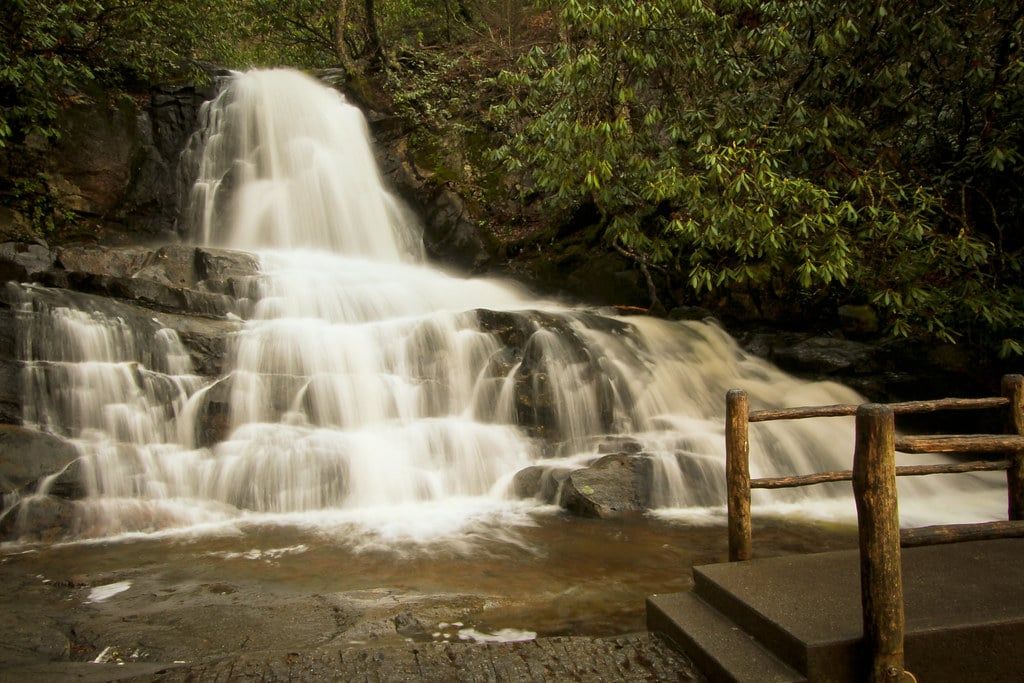
An 80-foot waterfall splits into upper and lower cascades along a paved 2.6-mile round trip, which made this the park's most popular hike for decades. It's closed as of January 2025 for rehabilitation — repaving, new viewing platforms, expanded parking — with a target reopening in summer 2026. Check the park's status page before you plan around it.
Sugarlands Valley and Cataract Falls
Sugarlands Valley Nature Trail is a flat, paved half-mile loop right by the visitor center, wide enough for a wheelchair or a double stroller. Cataract Falls, a 1.1-mile round trip from the same area, adds a modest waterfall without any real climbing. Neither will wow a seasoned hiker, but both are the right call with toddlers or grandparents in tow.
Grotto Falls via Trillium Gap
This is the only waterfall in the park you can walk behind, and standing in the spray under the rock overhang is worth the moderate climb through hemlock forest to get there. The trailhead sits on Roaring Fork Motor Nature Trail, which closes to vehicles from early December through late March — check that road's status before you drive up.
Gatlinburg Trail
This gentle path linking Sugarlands Visitor Center to downtown Gatlinburg is one of only two trails in the entire park where dogs are permitted, alongside the Oconaluftee River Trail, and both require a six-foot leash. It's also open to bikes, which makes it the default pick if you're traveling with a pet and still want a real walk in the woods.
Moderate Hikes: Best Bang-for-Your-Effort Views and Falls
Reasonably fit hikers with a half day can knock out any of these four and come home with a genuinely dramatic photo, not just a pleasant walk.
Abrams Falls Trail
Abrams Falls only drops about 20 to 25 feet, but it moves more water than any other waterfall in the park, and the wide plunge pool at the bottom makes it look bigger than the number suggests. The trail runs 5 miles round trip from Cades Cove, rolling over a few ridges rather than climbing steadily. Don't wade in — the current under that calm-looking surface has caused drownings, and swimming is discouraged park-wide.
Rainbow Falls Trail
At 80 feet, this is the tallest single-drop waterfall in the Smokies, and on sunny afternoons between about 1 and 3 p.m. the mist throws a rainbow across the base — hence the name. The climb is steady and occasionally steep over roughly 5.4 miles round trip. Go for the early-afternoon light and you'll skip the morning crowd that piles up at the trailhead lot.
Alum Cave Trail to the Bluffs
This is the geology hike: Arch Rock's natural stone tunnel, the narrow ledge at Inspiration Point, and finally the 80-foot concave bluff at Alum Cave itself, which isn't a true cave but shelters like one. The round trip to the bluffs runs about 4.4 miles with a steady, well-graded climb. It's also the first half of the much longer route up Mount LeConte, so plenty of hikers use it as a taste of that trail without committing to the whole day.
Andrews Bald
Andrews Bald is the easiest of the park's grassy balds to reach, a 3.6-mile round trip starting from the Kuwohi (Clingmans Dome) parking area, and one of only two balds the National Park Service actively maintains by mowing. The payoff is a wide-open meadow view of layered ridgelines with none of the crowd that packs the Kuwohi tower a mile away. Bring a picnic — this is the spot for it.
Strenuous Hikes: Summits, Balds, and All-Day Adventures
These are the trails experienced hikers put on a list before they even arrive — full days, real elevation, and the park's most dramatic views.
Mount LeConte via Alum Cave Trail
Mount LeConte is the third-highest peak in the Smokies at 6,593 feet, and this is the classic route up: roughly 11 to 11.2 miles round trip with about 2,760 to 3,077 feet of elevation gain, passing Arch Rock and Alum Cave Bluffs before the final push. At the top, Cliff Top and Myrtle Point give two different sunset-and-sunrise angles, and LeConte Lodge — the only non-camping lodging in the park, reachable solely on foot — sits just below the summit. If one big hike defines a Smokies trip, this is it.
Charlies Bunion and The Jump Off
Charlies Bunion is a bare rock outcrop on the Appalachian Trail, 8 to 8.1 miles round trip from Newfound Gap, with a drop-off view that feels far more exposed than the elevation numbers suggest. A short spur along the way leads to The Jump Off, an even more vertigo-inducing overlook worth the small detour. Afternoon storms roll in fast at this elevation in summer, so start early and watch the sky.
Chimney Tops Trail
Chimney Tops packs a steep, sustained climb into a short distance, which is why its reputation for burning quads outweighs its modest mileage. The final quarter-mile to the true twin-peak summit has been closed since the 2016 wildfires and shows no sign of reopening, but the trail still climbs to a solid rock overlook below it. Go for the workout and the view partway up, not the summit selfie you might remember from older photos online.
Ramsey Cascades
Ramsey Cascades is the tallest waterfall in the park at around 100 feet, and the 8-mile round trip to reach it runs through some of the largest old-growth trees left in the eastern United States. The last half-mile turns to a rock scramble alongside the creek, which is where most of the trail's elevation gain concentrates. Skip it after heavy rain — the rocks near the falls get slick and hikers have been hurt climbing on them.
Want an even longer day? Rocky Top and Thunderhead Mountain, reached via the Anthony Creek and Bote Mountain trails, and Mount Cammerer, with its stone fire tower on the park's eastern edge, both stretch past 10 miles round trip and see a fraction of the traffic on the marquee routes above. If a full day on foot isn't in the cards but you still want that ridge-top perspective, helicopter tours over the Smokies cover similar terrain in twenty minutes.
Underrated Trails Without the Crowds
Every trail above gets busy. These five, split between the Tennessee and North Carolina sides, don't — and several are just as good.
Porters Creek Trail
Porters Creek follows an old gravel road past the Elbert Cantrell farmstead and the Ownby Cemetery, remnants of the mountain communities the park displaced when it formed. Wildflowers peak here in April and May, carpeting the forest floor along the creek. For more on that settler history, the site's park history and visitor guide covers how these homesteads ended up inside a national park in the first place.
Baskins Creek Falls
This waterfall sits a short, moderate hike off the Roaring Fork Motor Nature Trail, and because there's no marquee name attached to it, the trailhead lot rarely fills. It's a solid substitute for Grotto Falls on a day when you want a waterfall and don't want to share it with fifty other cars.
Deep Creek Waterfall Loop
On the North Carolina side near Bryson City, this 2.4-mile loop passes three waterfalls — Juney Whank Falls, Indian Creek Falls, and Tom Branch Falls — in one easy circuit. It's also the park's best-known tubing spot in summer, so expect a family crowd near the creek even when the trail itself stays quiet. Most competitor guides barely mention the NC side; this loop is the reason to cross over.
Boogerman Trail and Cataloochee
Tucked in the remote Cataloochee Valley on the North Carolina side, Boogerman Trail winds through one of the park's largest surviving stands of old-growth forest, with tulip poplars and hemlocks that were never logged. Cataloochee is also the best place in the park to spot elk grazing at dawn and dusk. The valley's gravel access road keeps casual visitors away, which is exactly why hikers who make the drive have the trail to themselves.
Spruce Flat Falls
Near the Tremont Institute on the quieter western edge of the park, this short, moderately steep hike to a two-tiered waterfall stays off most visitors' radar simply because it's not on the way to Gatlinburg or Cades Cove. It's the pick for a quick, satisfying waterfall hike without a 7 a.m. alarm to beat the parking lot.
How to Choose the Right Hike for You
Match your priority to the list below instead of rereading the whole guide. If you're stacking several of these into one trip, the day-by-day itinerary guide shows how to sequence them without doubling back across the park.
- Best for kids and families: Sugarlands Valley, Cataract Falls, Grotto Falls, Deep Creek Loop.
- Best for waterfalls: Ramsey Cascades, Rainbow Falls, Abrams Falls, Grotto Falls.
- Best for panoramic views: Charlies Bunion, Mount LeConte, Andrews Bald, Chimney Tops.
- Best for solitude: Porters Creek, Baskins Creek Falls, Boogerman Trail.
- Best single bucket-list hike: Mount LeConte via Alum Cave Trail.
Practical Tips Before You Hike
A parking tag is required for any vehicle left longer than 15 minutes anywhere in the park — $5 for a day, $15 for a week, or $40 for the year — and it's separate from any interagency pass you already own. Buy it in advance through the park's hours and fees page rather than hunting for a machine at a crowded trailhead.
Popular lots fill by 8 or 9 a.m. from June through October, and a valid parking tag doesn't guarantee an actual spot. Arrive early, hike on a weekday if you can, and have a backup trail in mind. Cell service is unreliable to nonexistent through most of the park, so download an offline map before you leave range of a signal.
Black bears turn up on nearly every trail in this list. Keep at least 50 yards away, make noise on blind curves, and never approach one for a photo — it's a cited federal offense, not just bad judgment. Spring brings wildflowers and mild weather, summer brings crowds and sudden afternoon thunderstorms at elevation, and fall foliage in mid-October draws the heaviest traffic of the year. Winter trims the crowds but ices over anything above 4,000 feet, and both Kuwohi Road and Roaring Fork Motor Nature Trail typically close from early December through late March. For a fuller seasonal breakdown, see the month-by-month guide to visiting.
In September 2024, Clingmans Dome was officially renamed Kuwohi, Cherokee for 'mulberry place' — you'll see both names on older maps and signage for a while yet. With more than 12 million recreational visits in 2024, this is the most visited national park in the country, and that pressure shows up first as a full parking lot, not a crowded trail. If you're driving in from Knoxville or Asheville, check current road conditions on the park's directions and access page before you commit to a trailhead on the far side of the park.
Frequently asked questions
What is the most scenic hike in the Great Smoky Mountains?
Most hikers point to the Alum Cave Trail to Mount LeConte, an 11-mile round trip that mixes rock geology, old-growth forest, and summit views from Cliff Top and Myrtle Point. Charlies Bunion offers comparably dramatic panoramas in about 8 miles round trip if you want a shorter day.
What is the best easy hike in the Smoky Mountains?
Laurel Falls is the traditional answer — 2.6 miles round trip, paved, ending at an 80-foot waterfall — but it's closed for rehabilitation through summer 2026. Grotto Falls and Cataract Falls cover the same easy, family-friendly niche in the meantime.
How many miles of trails are in Great Smoky Mountains National Park?
The park has more than 800 miles of trail, including a stretch of the Appalachian Trail that runs along the Tennessee-North Carolina border for roughly 70 miles.
Do I need a permit or pass to hike in the Smokies?
No permit is needed for a day hike, but every vehicle parked more than 15 minutes needs a parking tag: $5 a day, $15 a week, or $40 a year. Overnight backcountry trips need a separate backcountry permit booked through the park's permit system.
Which Smoky Mountain hikes are best for families with young kids?
Sugarlands Valley Nature Trail (half a mile, paved, ADA-accessible) and Cataract Falls (1.1 miles) are the gentlest options. Grotto Falls and the Deep Creek Waterfall Loop suit slightly older kids who can handle a bit more distance and a little climbing.
Can I bring my dog on Smoky Mountain hiking trails?
Only on two trails in the entire park: the Gatlinburg Trail and the Oconaluftee River Trail, both on a six-foot leash. Dogs are prohibited on every other trail to protect wildlife and other hikers.
When is the best time of year to hike in the Smokies?
April and May bring wildflowers and mild weather; mid-October brings the best fall foliage but the heaviest crowds. Summer is lush but prone to afternoon thunderstorms and packed trailhead lots, while winter offers solitude alongside ice above 4,000 feet and seasonal closures on Kuwohi Road and Roaring Fork Motor Nature Trail.
Is the Kuwohi (Clingmans Dome) hike worth doing?
Yes — a steep half-mile paved path leads to the highest point in the park at 6,643 feet, with 360-degree views that reach into seven states on a clear day. It was officially renamed Kuwohi, Cherokee for 'mulberry place,' in September 2024.